The Cheyenne Office of the National Weather Service says severe storms are possible in southeast Wyoming today [June 22] and tomorrow.

The agency posted the following on its website:

Scattered severe thunderstorms will be possible this afternoon across southeast Wyoming and western Nebraska with large hail and damaging winds possible. Storms will begin early this afternoon west of I-25 in the Laramie Valley before moving east late in the afternoon. Low clouds along and east of I-25 through this morning will likely delay or limit thunderstorm development until later in the afternoon near Cheyenne, Wheatland, and point farther east. Be weather aware this afternoon and have multiple ways to receive warnings!

The agency says more severe weather is possible on Friday:

Scattered severe thunderstorms will be possible once again Friday afternoon with damaging winds and large hail possible once again. At this time, the focus area for severe storms shifts towards east-central Wyoming and much of the Nebraska Panhandle. For the latest forecast, be sure to check weather.gov/cys

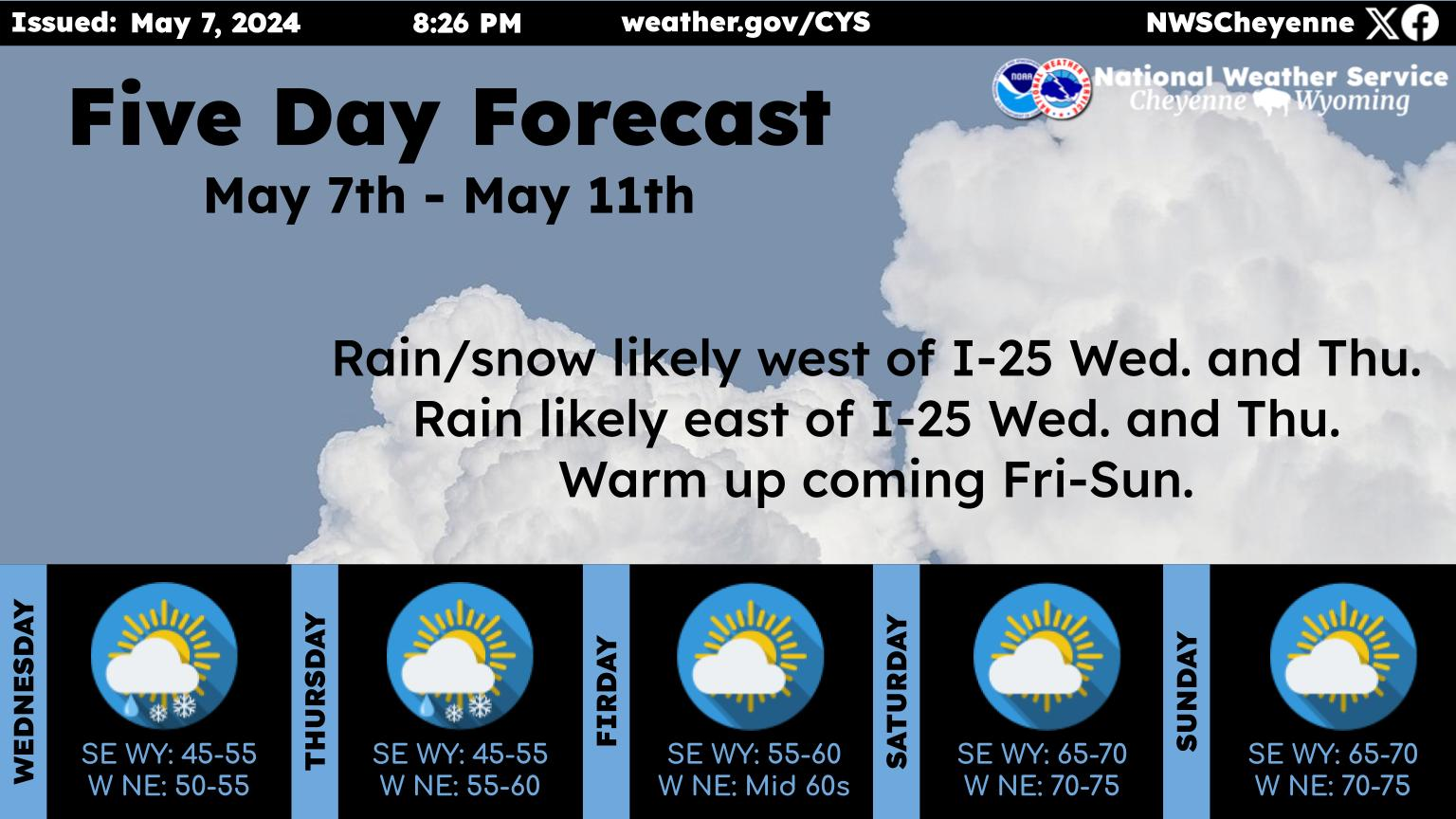
Here is the forecast for Cheyenne:

Today
Showers and thunderstorms. Some storms could be severe, with large hail and damaging winds. High near 68. East southeast wind 10 to 15 mph. Chance of precipitation is 80%. New rainfall amounts of less than a tenth of an inch, except higher amounts possible in thunderstorms.
Tonight
Showers and thunderstorms likely, mainly before 10pm. Some storms could be severe, with large hail and damaging winds. Mostly cloudy, with a low around 53. East southeast wind 5 to 15 mph. Chance of precipitation is 70%. New precipitation amounts between a tenth and quarter of an inch, except higher amounts possible in thunderstorms.
Friday
A 30 percent chance of showers and thunderstorms after noon. Some storms could be severe, with large hail and damaging winds. Partly sunny, with a high near 77. South wind 10 to 15 mph.
Friday Night
A 20 percent chance of showers and thunderstorms before midnight. Some storms could be severe, with large hail and damaging winds. Mostly clear, with a low around 49. Breezy, with a south wind 15 to 20 mph becoming northwest after midnight.
Saturday
Sunny, with a high near 77. Windy, with a west wind 15 to 20 mph increasing to 25 to 30 mph in the afternoon. Winds could gust as high as 40 mph.
Saturday Night
Mostly clear, with a low around 47. Breezy.
Sunday
Sunny, with a high near 73.
Sunday Night
Mostly clear, with a low around 50.
Monday
A slight chance of showers and thunderstorms after noon. Sunny, with a high near 78.
Monday Night
A slight chance of showers and thunderstorms before midnight. Mostly clear, with a low around 53.
Tuesday
A slight chance of showers and thunderstorms. Sunny, with a high near 78.
Tuesday Night
A slight chance of showers and thunderstorms. Partly cloudy, with a low around 55.
Wednesday
A slight chance of showers and thunderstorms. Sunny, with a high near 81. Breezy
Here is the Laramie forecast:
Today Showers and thunderstorms likely before 1pm, then showers and possibly a thunderstorm between 1pm and 3pm, then showers and thunderstorms after 3pm. Some storms could be severe, with large hail and damaging winds. High near 59. East southeast wind 10 to 15 mph. Chance of precipitation is 90%. New rainfall amounts between a tenth and quarter of an inch, except higher amounts possible in thunderstorms.
Tonight
Showers and thunderstorms likely, mainly before 10pm. Some storms could be severe, with large hail and damaging winds. Mostly cloudy, with a low around 48. Southeast wind 10 to 15 mph. Chance of precipitation is 70%. New precipitation amounts between a tenth and quarter of an inch, except higher amounts possible in thunderstorms.
Friday
A 20 percent chance of showers and thunderstorms after noon. Sunny, with a high near 71. Breezy, with a south wind 10 to 15 mph increasing to 15 to 20 mph in the afternoon. Winds could gust as high as 30 mph.
Friday Night
Mostly clear, with a low around 46. Windy, with a west wind 20 to 25 mph increasing to 25 to 30 mph after midnight. Winds could gust as high as 45 mph.
Saturday
Sunny, with a high near 67. Windy, with a west wind 30 to 35 mph, with gusts as high as 55 mph.
Saturday Night
Mostly clear, with a low around 43. Windy.
Sunday
Sunny, with a high near 68. Breezy.
Sunday Night
Mostly clear, with a low around 47.
Monday
A slight chance of showers and thunderstorms after noon. Sunny, with a high near 73. Breezy.
Monday Night
A slight chance of showers before midnight. Partly cloudy, with a low around 49. Breezy.
Tuesday
A chance of showers and thunderstorms. Mostly sunny, with a high near 72. Breezy.
Tuesday Night
A slight chance of showers and thunderstorms. Partly cloudy, with a low around 52.
Wednesday
A slight chance of showers and thunderstorms. Mostly sunny, with a high near 73. Breezy.

What $1,000+ a Night Gets You at Cheyenne Airbnbs During Frontier Days.

Airbnb homes around Cheyenne are popping up with outrageous prices for travelers staying during the 2023 Cheyenne Frontier Days. Pros: Most of the rentals are at least 2 bedrooms, some are super close to Frontier Park, and all of them have decent kitchens and bathrooms. Cons: Most don't have Central A/C, and all of them are $1,000+ a night.