Southeast Wyoming is facing an "active weather pattern" over the next week, according to the Cheyenne Office of the National Weather Service.

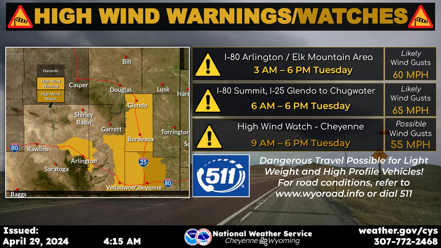
That is expected to include warming and cooling weather, strong winds, blowing snow and possibly artic weather towards mid-week next week.


Cheyenne and Laramie both could see lows in the sub-zero range.

That's according to a post on the agency's website:

Very active weather is expected for the week ahead. We will break out of the most recent cold snap today with temperatures returning to slightly above normal. Expect a cool down Sunday, followed by a rebound for Monday. Big changes are expected by Wednesday with a return of arctic cold possible, though significant uncertainty remains. Strong winds will be the main concern through Tuesday. The wind prone areas can expect high winds today, then again on Saturday night/early Sunday, and again on Sunday night through Monday and possibly into Tuesday. Very strong winds could become widespread on Sunday night and Monday. Snowfall will return to the higher terrain on Sunday, and continue on and off through the week ahead. More widespread snow is possible late Tuesday through early Thursday, but uncertainty remains high regarding the details of this system. Keep checking back for more information in the coming days!

Here is the forecast for Cheyenne:

Today
Sunny, with a high near 49. Breezy, with a west southwest wind 15 to 20 mph, with gusts as high as 30 mph.
Tonight
Mostly cloudy, with a low around 27. West wind around 10 mph.
Saturday
Partly sunny, with a high near 48. Breezy, with a west wind 10 to 20 mph.
Saturday Night
Mostly cloudy, with a low around 28. Breezy, with a west wind 20 to 25 mph, with gusts as high as 40 mph.
Sunday
Mostly sunny, with a high near 38. Windy, with a west northwest wind 20 to 30 mph, with gusts as high as 45 mph.
Sunday Night
Patchy blowing snow between 10pm and 11pm. Partly cloudy, with a low around 29. Windy.
Washington's Birthday
Partly sunny, with a high near 48. Windy.
Monday Night
A chance of snow. Mostly cloudy, with a low around 31. Windy.
Tuesday
A chance of snow. Partly sunny, with a high near 47. Breezy.
Tuesday Night
Snow likely. Mostly cloudy, with a low around 10.
Wednesday
Snow likely. Cloudy, with a high near 20. Blustery.
Wednesday Night
Snow likely. Mostly cloudy, with a low around -7. Blustery.
Thursday
A chance of snow. Partly sunny, with a high near 18.
Here is the for Laramie:
Today
Sunny, with a high near 40. Breezy, with a west southwest wind 15 to 20 mph, with gusts as high as 30 mph.
Tonight
Partly cloudy, with a low around 17. Southwest wind 10 to 15 mph.
Saturday
Mostly sunny, with a high near 40. Breezy, with a west southwest wind 10 to 15 mph increasing to 15 to 20 mph in the afternoon. Winds could gust as high as 30 mph.
Saturday Night
Mostly cloudy, with a low around 20. Breezy, with a west wind around 20 mph, with gusts as high as 30 mph.
Sunday
A 20 percent chance of snow showers before 11am. Partly sunny, with a high near 31. Windy, with a west wind 15 to 20 mph increasing to 25 to 30 mph in the afternoon. Winds could gust as high as 45 mph.
Sunday Night
Partly cloudy, with a low around 23. Windy.
Washington's Birthday
A 30 percent chance of snow after 11am. Partly sunny, with a high near 38. Windy.
Monday Night
A chance of snow. Mostly cloudy, with a low around 29. Windy.
Tuesday
A chance of snow. Mostly cloudy, with a high near 40. Windy.
Tuesday Night
Snow likely. Mostly cloudy, with a low around 13. Breezy.
Wednesday
Snow likely. Cloudy, with a high near 23.
Wednesday Night
Snow likely. Mostly cloudy, with a low around -8.
Thursday
A slight chance of snow. Partly sunny, with a high near 21.

Best Playground in Cheyenne, According to Locals