It looks like winter has arrived with a vengeance in southeast Wyoming, with very cold temperatures, even colder wind chills and yes, more snow in the forecast for Cheyenne and Laramie.

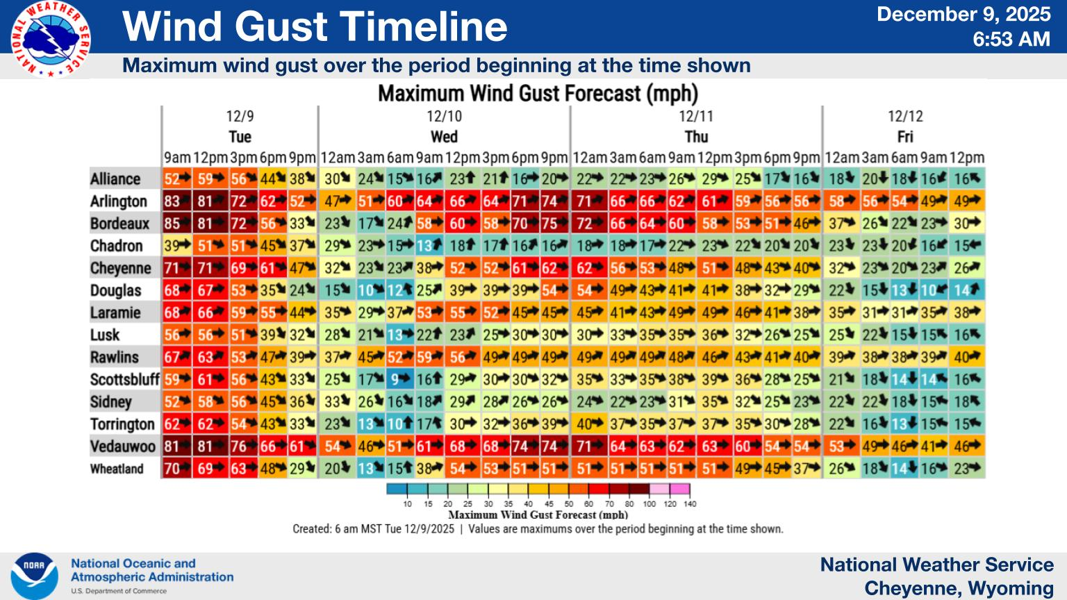
That's according to the Cheyenne Office of the National Weather Service. The agency posted the following on it's website. Keep in mind the graphic is talking about actual temperatures, not wind chills:

A combination of cold air aloft, newly developed snowpack, and clearing skies will help drop overnight temperatures significantly for a cold start for Friday and Saturday morning. Some fog may develop in the Central Panhandle from Scottsbluff to Alliance that may help insulate this area and stabilize temperatures a little bit warmer than forecasted. Friday night, a little bit warmer air moves in aloft. This warmer air may help temperatures stay in the positives despite another inch or two of snow dropping Friday Night.


Cheyenne, Laramie Forecasts

Cheyenne Forecast

Tonight
A 10 percent chance of snow showers after 5am. Partly cloudy, with a low around 0. Northwest wind around 5 mph becoming calm after midnight.
Friday
Snow showers likely, mainly between 11am and 2pm. Increasing clouds, with a high near 25. Calm wind becoming east southeast around 5 mph in the morning. Chance of precipitation is 60%. New snow accumulation of less than one inch possible.
Friday Night
A 40 percent chance of snow showers before 11pm. Mostly cloudy, then gradually becoming mostly clear, with a low around 9. Wind chill values between zero and 5. North northeast wind 5 to 10 mph becoming west in the evening.
Saturday
Sunny, with a high near 39. West northwest wind 10 to 15 mph.
Saturday Night
Mostly clear, with a low around 11.
Sunday
Sunny, with a high near 42.
Sunday Night
Partly cloudy, with a low around 19.
Monday
Partly sunny, with a high near 56.
Monday Night
Mostly cloudy, with a low around 32.
Tuesday
Partly sunny, with a high near 58. Breezy.
Tuesday Night
A chance of rain and snow showers. Mostly cloudy, with a low around 32. Breezy.
Wednesday
A chance of rain and snow showers. Mostly sunny, with a high near 51. Breezy.
Wednesday Night
A chance of rain and snow showers. Partly cloudy, with a low around 28.
Thursday
A chance of snow showers. Mostly sunny, with a high near 53. Breezy.
Laramie Forecast
Tonight
Partly cloudy, with a low around 3. Wind chill values between -5 and -10. West wind 10 to 15 mph becoming south after midnight.
Friday
Snow showers likely, mainly after 11am. Mostly cloudy, with a high near 18. Wind chill values between -10 and zero. South southeast wind 10 to 15 mph becoming east northeast in the afternoon. Chance of precipitation is 60%. New snow accumulation of around an inch possible.
Friday Night
A 40 percent chance of snow showers before 11pm. Mostly cloudy, then gradually becoming mostly clear, with a low around 8. Wind chill values between -10 and zero. Breezy, with a north northwest wind 10 to 15 mph becoming west 15 to 20 mph after midnight. Winds could gust as high as 30 mph.
Saturday
Sunny, with a high near 25. Breezy, with a west wind 15 to 25 mph, with gusts as high as 35 mph.
Saturday Night
Mostly clear, with a low around 12.
Sunday
Sunny, with a high near 35.
Sunday Night
Mostly clear, with a low around 21.
Monday
Partly sunny, with a high near 43. Breezy.
Monday Night
Mostly cloudy, with a low around 30. Breezy.
Tuesday
Partly sunny, with a high near 43. Breezy.
Tuesday Night
A chance of snow showers. Mostly cloudy, with a low around 29. Breezy.
Wednesday
A chance of snow showers. Partly sunny, with a high near 36. Windy.
Wednesday Night
A chance of snow showers. Partly cloudy, with a low around 25. Breezy.
Thursday
A chance of snow showers. Mostly sunny, with a high near 38. Windy.

Penny's Diner At Bill Wyoming

Gallery Credit: Glenn Woods