The Cheyenne Office of the National Weather Service says strong to severe thunderstorms are possible in southeast Wyoming on July 4th.

Both Cheyenne and Laramie are at risk for the severe weather. [see map below].

The agency posted this map and graphic on its website:

There is a Slight Risk for severe thunderstorms along portions of the Interstate 80 corridor including Cheyenne and Laramie today, with a Marginal Risk extending north towards the North Platte River Valley. Thunderstorms will develop quickly later this morning with storms becoming strong to severe as early as noon. Multiple lines of thunderstorms are expected as a surface cold front slowly moves south into Colorado this afternoon and stalls across the mountains.

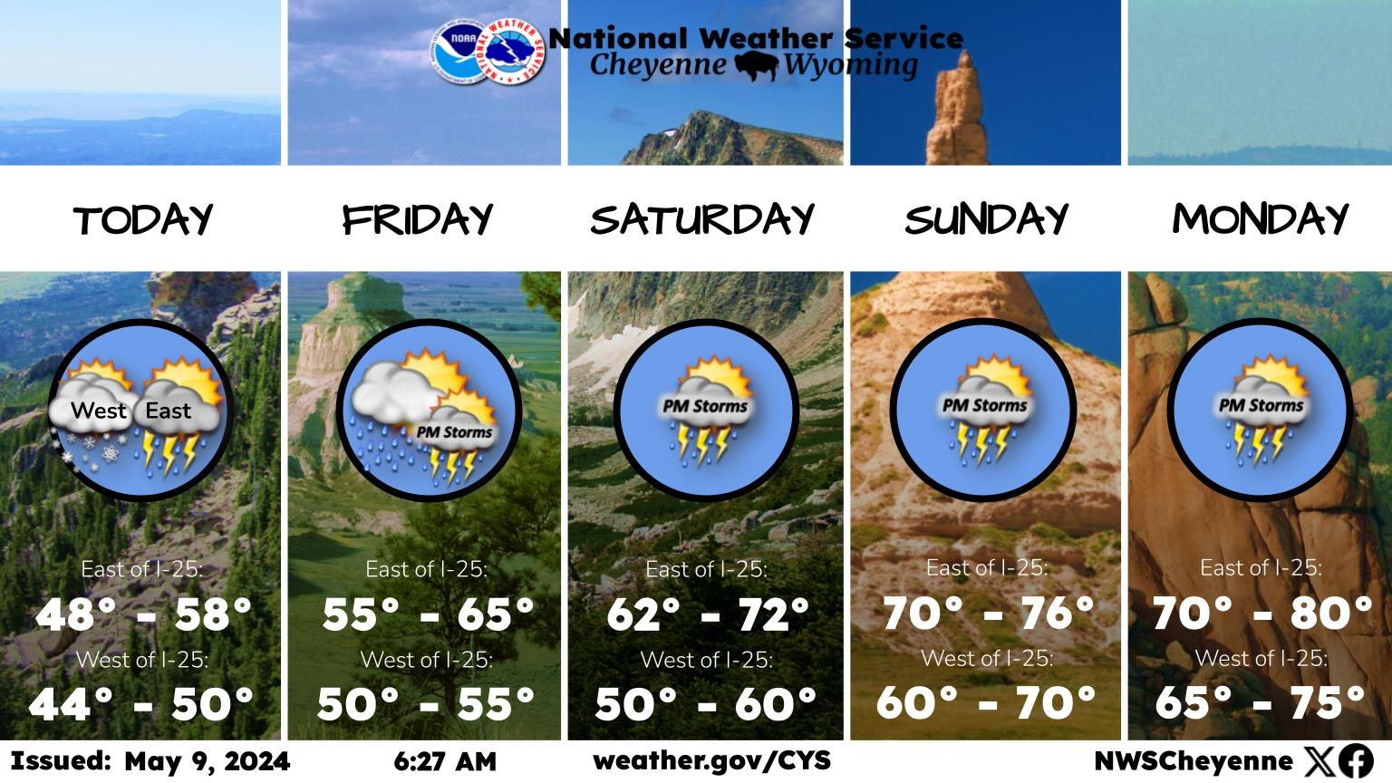
Here is the Cheyenne forecast:

Independence Day
A slight chance of showers, then showers and possibly a thunderstorm after noon. Some storms could be severe, with large hail and damaging winds. High near 74. Northwest wind around 15 mph becoming north northeast in the afternoon. Chance of precipitation is 80%. New rainfall amounts between a quarter and half of an inch possible.
Tonight
Showers and thunderstorms likely before 9pm, then showers likely and possibly a thunderstorm after 9pm. Some storms could be severe, with large hail and damaging winds. Patchy fog before midnight, then patchy fog after 2am. Otherwise, mostly cloudy, with a low around 47. North wind 10 to 15 mph becoming east northeast 5 to 10 mph after midnight. Winds could gust as high as 25 mph. Chance of precipitation is 70%. New rainfall amounts between a quarter and half of an inch possible.
Wednesday
A 40 percent chance of showers and thunderstorms. Patchy fog before 4pm. Otherwise, cloudy, with a high near 55. East southeast wind 5 to 10 mph.
Wednesday Night
A 20 percent chance of showers and thunderstorms. Patchy fog after 8pm. Otherwise, mostly cloudy, with a low around 49. South wind around 10 mph.
Thursday
A 40 percent chance of showers and thunderstorms after noon. Partly sunny, with a high near 75. South wind 10 to 15 mph.
Thursday Night
A 40 percent chance of showers and thunderstorms before midnight. Some of the storms could be severe. Mostly cloudy, with a low around 52.
Friday
A 40 percent chance of showers and thunderstorms after noon. Mostly sunny, with a high near 78.
Friday Night
A chance of showers and thunderstorms before midnight. Partly cloudy, with a low around 52.
Saturday
A chance of showers and thunderstorms after noon. Mostly sunny, with a high near 76.
Saturday Night
A chance of showers and thunderstorms before midnight. Partly cloudy, with a low around 54.
Sunday
A slight chance of showers and thunderstorms. Sunny, with a high near 81. Breezy.
Sunday Night
Mostly clear, with a low around 54. Breezy.
Monday
A slight chance of showers and thunderstorms. Sunny, with a high near 81.
Here is the Laramie forecast:
Independence Day
A slight chance of showers, then showers and possibly a thunderstorm after noon. Some storms could be severe, with large hail and damaging winds. High near 68. Breezy, with a west northwest wind 10 to 20 mph becoming north northeast in the afternoon. Winds could gust as high as 30 mph. Chance of precipitation is 80%. New rainfall amounts between a quarter and half of an inch possible.
Tonight
Showers and thunderstorms likely before 9pm, then showers likely and possibly a thunderstorm between 9pm and midnight, then a chance of showers and thunderstorms after midnight. Some storms could be severe, with large hail and damaging winds. Patchy fog before 4am, then patchy fog after 5am. Otherwise, mostly cloudy, with a low around 41. Breezy, with a northeast wind 10 to 20 mph becoming east southeast after midnight. Winds could gust as high as 30 mph. Chance of precipitation is 70%. New rainfall amounts between a quarter and half of an inch possible.
Wednesday
A 30 percent chance of showers and thunderstorms. Patchy fog before 1pm. Otherwise, mostly sunny, with a high near 54. Southeast wind around 15 mph.
Wednesday Night
Partly cloudy, with a low around 45. South southeast wind 10 to 15 mph.
Thursday
A 40 percent chance of showers and thunderstorms after noon. Partly sunny, with a high near 69. South wind 10 to 15 mph becoming west northwest in the afternoon. Winds could gust as high as 25 mph.
Thursday Night
A 30 percent chance of showers and thunderstorms before midnight. Mostly cloudy, with a low around 48.
Friday
A 50 percent chance of showers and thunderstorms after noon. Sunny, with a high near 70.
Friday Night
A slight chance of showers and thunderstorms before midnight. Partly cloudy, with a low around 48.
Saturday
A chance of showers and thunderstorms after noon. Mostly sunny, with a high near 68.
Saturday Night
A slight chance of showers and thunderstorms before midnight. Partly cloudy, with a low around 50.
Sunday
A slight chance of showers and thunderstorms. Sunny, with a high near 72. Breezy.
Sunday Night
Partly cloudy, with a low around 50. Breezy.
Monday
A slight chance of showers and thunderstorms. Sunny, with a high near 75.

Check Out the Sun Halos Above Cheyenne

The amazing natural phenomenon began Thursday morning. A dazzling double halo, sun dogs, and rainbows appeared in the blue skies above Cheyenne.