High wind warnings have been issued for areas of southeast Wyoming starting at 5 p.m. today and continuing into Tuesday at 11 a.m., according to the Cheyenne Office of the National Weather Service.

The agency posted the following on its website:

Cheyenne and Laramie could also see snow today and tonight, and again later this week.

And Laramie could see wind chills into the sub-zero range for tonight.

Greetings! No relief for the wind weary folks of southeast Wyoming, sorry to say! High Wind Warnings have been posted for the wind prone areas of southeast Wyoming, from 5PM this afternoon through 11AM Tuesday. Westerly wind gusts of 65-70 mph can be expected along Interstate 80 near Arlington/Elk Mountain as well as the I-80 Summit area between Cheyenne and Laramie. On Interstate 25, mile marker 4 as well as Bordeaux expected to see these windspeeds as well.

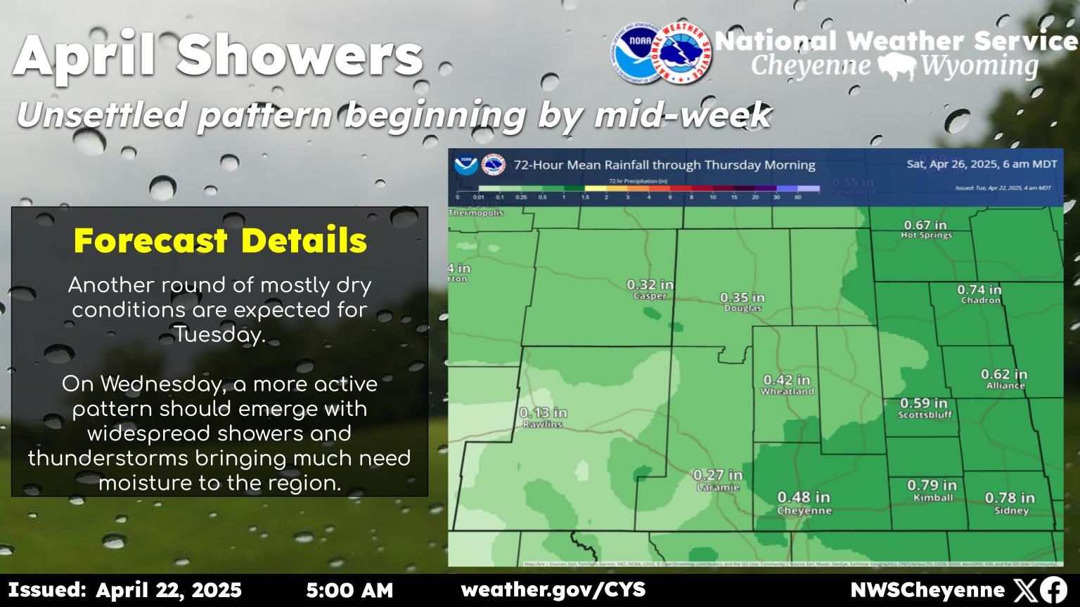
Snow In The Forecast for Cheyenne, Laramie

Cheyenne Forecast:

Today
A 40 percent chance of snow, mainly after 1pm. Partly sunny, with a high near 37. Southwest wind around 15 mph.
Tonight
A 20 percent chance of snow before midnight. Partly cloudy, with a low around 18. West northwest wind 10 to 15 mph.
Tuesday
Mostly sunny, with a high near 41. Breezy, with a south southwest wind 10 to 20 mph, with gusts as high as 30 mph.
Tuesday Night
Partly cloudy, with a low around 23. South southwest wind 10 to 15 mph.
Wednesday
Mostly sunny, with a high near 48. West southwest wind 5 to 10 mph.
Wednesday Night
A 20 percent chance of snow. Mostly cloudy, with a low around 24.
Thursday
A 50 percent chance of snow, mainly after noon. Mostly cloudy, with a high near 43.
Thursday Night
Snow likely, mainly before midnight. Mostly cloudy, with a low around 21.
Friday
A chance of snow. Mostly cloudy, with a high near 35.
Friday Night
Partly cloudy, with a low around 18.
Saturday
Sunny, with a high near 46.
Saturday Night
Mostly clear, with a low around 23.
Sunday
Mostly sunny, with a high near 51.
Laramie Forecast:
Today
A 50 percent chance of snow, mainly after 1pm. Patchy blowing snow after 1pm. Partly sunny, with a high near 34. Breezy, with a west southwest wind 15 to 25 mph, with gusts as high as 30 mph.
Tonight
A 20 percent chance of snow before midnight. Patchy blowing snow before 9pm. Partly cloudy, with a low around 14. Wind chill values between -5 and 5. Breezy, with a west wind 15 to 20 mph, with gusts as high as 30 mph.
Tuesday
Patchy blowing snow between 10am and noon. Partly sunny, with a high near 40. Wind chill values between zero and 10. Breezy, with a southwest wind 15 to 20 mph, with gusts as high as 30 mph.
Tuesday Night
Mostly cloudy, with a low around 23. Southwest wind 10 to 15 mph.
Wednesday
Mostly sunny, with a high near 43. West southwest wind 10 to 15 mph.
Wednesday Night
Mostly cloudy, with a low around 21.
Thursday
A 50 percent chance of snow after noon. Mostly cloudy, with a high near 40.
Thursday Night
A chance of snow. Mostly cloudy, with a low around 21.
Friday
A chance of snow. Mostly cloudy, with a high near 33.
Friday Night
Partly cloudy, with a low around 13.
Saturday
Sunny, with a high near 41.
Saturday Night
Mostly clear, with a low around 19.
Sunday
Mostly sunny, with a high near 45.

10 Commandments of Wyoming Winter Driving

Gallery Credit: DJ Nyke