While the next few days in southeast Wyoming are expected to feature summer-like weather, a blast of winter could be headed our way before too long.

That's according to the Cheyenne Office of the National Weather Service.

The agency posted the following on its website:

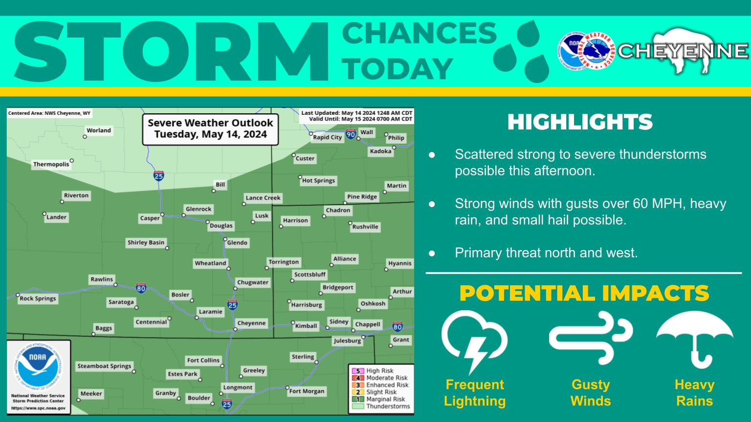
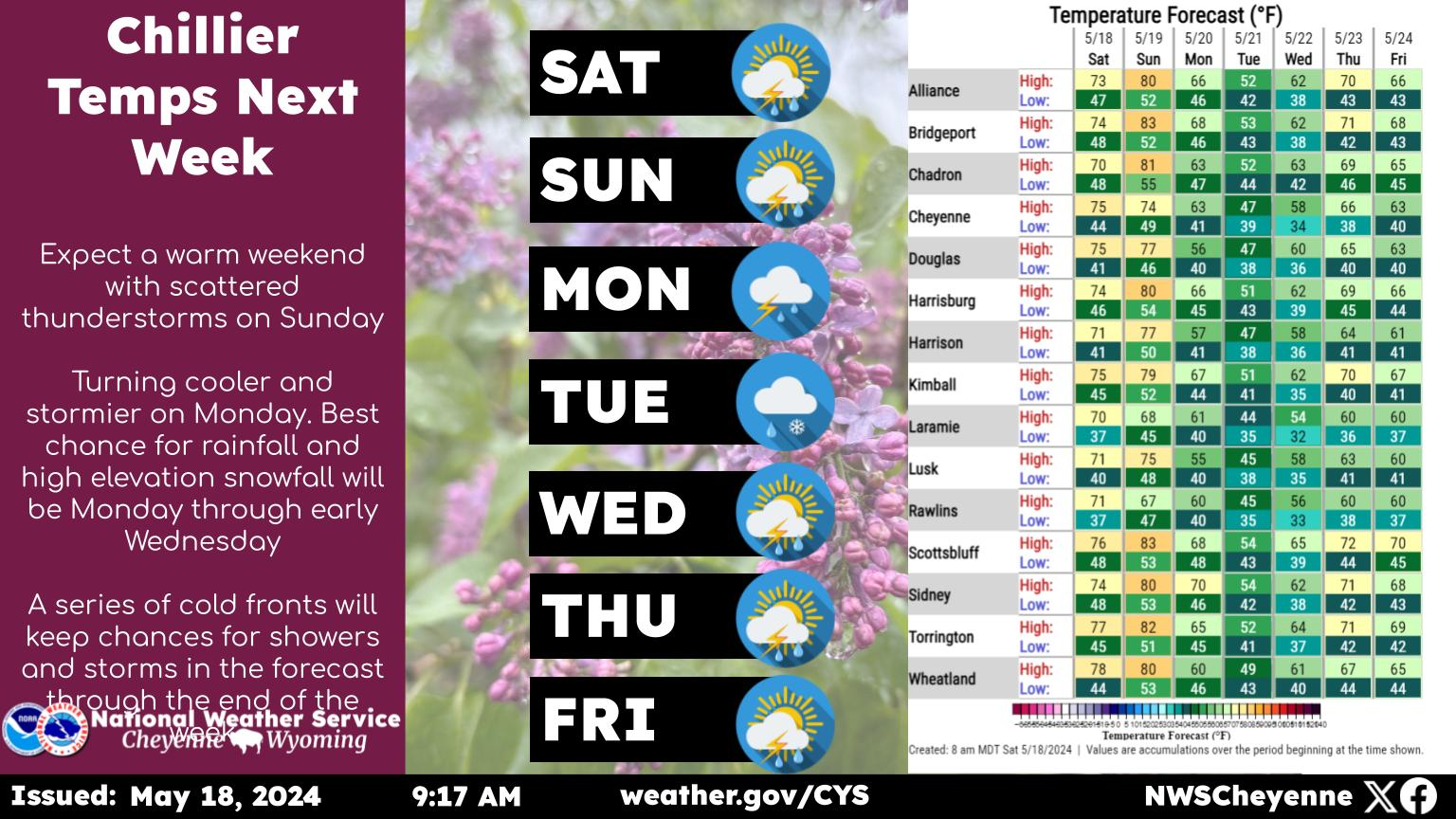
Heads up for an unsettled weather pattern returning next week across southeast Wyoming and Nebraska Panhandle. The high pressure that has been giving us the great Fall weather is going to break down, opening the area for several cold fronts to move through. Nice weather Sunday and most of Monday. We begin to see the first cold front Monday afternoon, that will bring rain showers to areas west of the Laramie Range. Next cold front Wednesday and then a much stronger (and colder) arctic front is possible Thursday into Friday next week. This arctic front may bring very cold temperatures and widespread snow to all areas the end of next week. If making travel or recreation plans next week, keep an eye on the forecast. Stay tuned!


But the next few days should be very nice:

Couldn't ask for better weather across southeast Wyoming and Nebraska Panhandle the next few days. With sunny skies, dry weather and warm temperatures, it doesn't feel like October. Warmest day expected to be Friday, when 80s return to the Panhandle and 70s for most of southeast Wyoming. No weather impacts expected through Saturday. Enjoy!

Here is the Cheyenne Forecast:

Today
Sunny, with a high near 75. Breezy, with a northwest wind 15 to 20 mph.
Tonight
Clear, with a low around 46. West northwest wind around 10 mph.
Friday
Sunny, with a high near 80. West northwest wind 10 to 15 mph.
Friday Night
Mostly clear, with a low around 42. North wind 5 to 10 mph becoming west southwest after midnight.
Saturday
Sunny, with a high near 68. West southwest wind 5 to 15 mph becoming southeast in the afternoon.
Saturday Night
Partly cloudy, with a low around 40.
Sunday
Sunny, with a high near 69.
Sunday Night
Partly cloudy, with a low around 42.
Monday
A slight chance of rain after noon. Mostly sunny, with a high near 69.
Monday Night
A chance of rain, mainly before midnight. Mostly cloudy, with a low around 37.
Tuesday
A chance of rain. Partly sunny, with a high near 55.
Tuesday Night
A slight chance of rain. Partly cloudy, with a low around 34.
Wednesday
A slight chance of rain. Sunny, with a high near 59.
Here is the Laramie forecast:
Today
Sunny, with a high near 67. Breezy, with a west northwest wind 15 to 20 mph, with gusts as high as 30 mph.
Tonight
Clear, with a low around 48. Breezy, with a west wind 10 to 20 mph, with gusts as high as 30 mph.
Friday
Sunny, with a high near 71. Breezy, with a west wind 10 to 20 mph, with gusts as high as 30 mph.
Friday Night
Mostly clear, with a low around 43. Northwest wind around 10 mph becoming west southwest after midnight.
Saturday
Mostly sunny, with a high near 64. West southwest wind 5 to 10 mph becoming south southeast in the afternoon.
Saturday Night
Partly cloudy, with a low around 43.
Sunday
Mostly sunny, with a high near 64.
Sunday Night
Partly cloudy, with a low around 43.
Monday
A slight chance of rain after noon. Mostly sunny, with a high near 60.
Monday Night
A chance of rain, mainly before midnight. Mostly cloudy, with a low around 37.
Tuesday
A chance of rain. Partly sunny, with a high near 51.
Tuesday Night
A slight chance of rain. Partly cloudy, with a low around 35.
Wednesday
A slight chance of rain. Mostly sunny, with a high near 54. Breezy.

Bighorn Sheep in Wyoming

Gallery Credit: Kolby Fedore, TSM