
Blizzard Warning For Laramie Area Saturday into Sunday
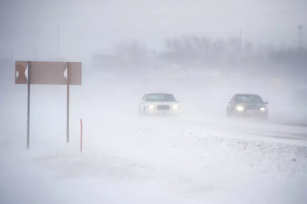
With a winter storm bearing down southeast Wyoming, the National Weather Service has issued a Blizzard Warning for parts of Wyoming, including Albany County, the I-80 Summit, and the city of Laramie. The Warning is in effect from late Saturday night through Monday morning.
A Winter Storm Warning remains in effect for the area from Friday night through Saturday night. Travel is expected to become difficult if not impossible as we move through the weekend.
For the Winter Storm Warning, freezing drizzle changing over to heavy snow expected. Total snow accumulations of 8 to 12 inches and ice accumulations of around one tenth of an inch. Winds gusting as high as 50 mph.
For the Blizzard Warning, blizzard conditions expected. Total snow accumulations of 20 to 29 inches. Winds gusting as high as 60 mph.

URGENT - WINTER WEATHER MESSAGE
National Weather Service Cheyenne WY
211 PM MST Fri Mar 12 2021


...HISTORIC WINTER STORM ABOUT TO IMPACT SOUTHEAST WYOMING AND
NEBRASKA PANHANDLE THIS WEEKEND...

...WINTER STORM WARNING IN EFFECT FOR MAJORITY OF SOUTHEAST
WYOMING AND NEBRASKA PANHANDLE TONIGHT THROUGH MONDAY MORNING...

Central Laramie Range and Southwest Platte County-
East Platte County-Goshen County-North Snowy Range Foothills-
Laramie Valley-South Laramie Range-South Laramie Range Foothills-
Including the cities of Bordeaux, Wheatland, Guernsey,
Torrington, Arlington, Elk Mountain, Bosler, Laramie, Buford,
Pumpkin Vine, Vedauwoo, Whitaker, Federal, and Horse Creek
211 PM MST Fri Mar 12 2021

...WINTER STORM WARNING NOW IN EFFECT FROM 11 PM THIS EVENING TO
11 PM MST SATURDAY...
...BLIZZARD WARNING IN EFFECT FROM 11 PM MST SATURDAY TO 6 AM MDT
MONDAY...

* WHAT...For the Winter Storm Warning, freezing drizzle changing
  over to heavy snow expected. Total snow accumulations of 8 to 12
  inches and ice accumulations of around one tenth of an inch.
  Winds gusting as high as 50 mph. For the Blizzard Warning,
  blizzard conditions expected. Total snow accumulations of 20 to
  29 inches. Winds gusting as high as 60 mph.

* WHERE...Platte...Goshen...Laramie Range...Laramie Valley and
  extreme southeast Carbon County to include the towns of
  Torrington...Wheatland...Chugwater...Laramie...Arlington...Elk
  Mountain...Buford and Vedauwoo.

* WHEN...For the Winter Storm Warning, from 11 PM this evening
  to 11 PM MST Saturday. For the Blizzard Warning, from 11 PM
  MST Saturday to 6 AM MDT Monday.

* IMPACTS...Travel could be very difficult to impossible. Areas
  of blowing snow could significantly reduce visibility. Strong
  winds could cause extensive damage to trees and power lines.

PRECAUTIONARY/PREPAREDNESS ACTIONS...

If you must travel, keep an extra flashlight, food, and water in
your vehicle in case of an emergency.

Travel should be restricted to emergencies only. If you must
travel, have a winter survival kit with you. If you get stranded,
stay with your vehicle.

The latest road conditions for the state you are calling from can
be obtained by calling 5 1 1.
TIPS: Here's how you can prepare for power outages
More From Y95 Country


![Kenny Chesney’s Past and Present Are Connected By the Sea in ‘Knowing You’ Video [Watch]](http://townsquare.media/site/204/files/2021/03/kenny-chesney-knowing-you-video.jpg?w=980&q=75)

